 www.geodatenkatalog.de (S1F)
Keyword
German EEZ
8 record(s)
Provided by
Type of resources
Available actions
Topics
Keywords
Contact for the resource
Update frequencies
Service types
-
The data represent the calculated yields of wind farms in the exclusive economic zone (EEZ) in full load hours per wind farm expansion area, assuming an expansion of offshore wind energy defined in different scenarios. The calculations were carried out with the numerical weather model WRF using a parameterization of wind farms according to Fitch. The results refer to the areas in the North Sea and the meteorological year 2006.
-
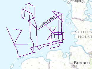
Continuing the systematic work which was started during a previous BGR expedition with RV AURELIA in Sept./Oct. 2003 the late Tertiary and Quaternary development of the German EEZ was further investigated by seismic profiling. The data format is Society of Exploration Geophysicists SEG Y. Again the research vessel AURELIA was chartered for a period of 21 days from 31st of May to 19th of June 2004. During the cruise the grid of seismic profiles which was aquired in 2003 was completed and data gaps were closed. A total of 2618km of high quality MCS lines were surveyed.
-
The previous BGR-cruises with RV AURELIA in 2003 and 2004 and RV HEINCKE in 2005 and RV ALKOR in 2006 were designed to collect a grid of seismic MCS-data which should enable us to get a high-resolution overview over the upper 1-2 s TWT of the sediments of the German North Sea sector. The data format is Society of Exploration Geophysicists SEG Y. The aim of this cruise was a detailed survey in the north westernmost area of the German EEZ (exclusive economic zone), the so-called ‘Entenschnabel’ and additionally a mapping of special glacial structures off Sylt Island. The cruise was subdivided into two Legs. One outreaching additional aim was to extend the results from the previous cruises for the Late Tertiary and Quaternary sedimentary evolution into the ‘Entenschnabel’-area which was virtually unexplored by systematic shallow high-resolution seismics. During Leg 1 the BGR high-resolution multichannel seismic reflection system consisting of a GI-Gun (0.8 l) and a 500 m streamer with 36 channels and a shallow swath bathymetric system, type SIMRAD EM1200 by Kongsberg, Bergen, Norway were used. While the BGR-seismic system was used to observe the shallow subsurface down to 2 s TWT penetration depth, the swath bathymetric system was used to identify possible pockmark locations as well as sampling positions for the deployment of the BGR vibration corer during the succeeding Leg 2. All seismic records were processed onboard for the quality control and for a first interpretation loaded into GEOQUEST.
-
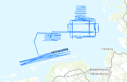
The previous BGR-cruises with RV AURELIA in 2003 and 2004 were designed to collect a grid of seismic MCS-data which should enable us to get a high-resolution overview over the upper 1 s TWT of the sediments of the German North Sea sector. The data format is Society of Exploration Geophysicists SEG Y. Together with the previously acquired data these new data should help to extend our knowledge of the Late Tertiary and Quaternary evolution of the German North Sea Sector. For the current measurements under the scope of the DFG-funded project RE2424/1-1 ‚Nordsee’ the research vessel RV HEINCKE was made available by the ‘Senatskommission für Ozeanographie’ of the DFG. During the cruise a total ca. 1400 km of high quality MCS lines were surveyed and simultaneously measured by a sediment echosounder system that enabled additional profiles during transits with speeds > 5 kn. The BGR high-resolution multichannel seismic reflection system consisting of a GI-Gun (0.8 l) and a 300 m streamer with 24 channels and a sediment echosounder type SES 2000 standard by Innomar, Rostock. While the BGR-seismic system was used to observe the shallow subsurface down to 2 s TWT penetration depth, the sediment echosounder with a penetration depth of several meters was primarily intended to identify sampling positions for the deployment of the BGR vibration corer during the succeeding Leg 2. Additionally, the echosounder system enables the relationship to the highest-resolution multichannel seismic measurements of the group of the University of Bremen on FK SENCKENBERG. All seismic records were processed onboard for the quality control and for a first interpretation.
-
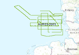
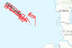
The late Tertiary and Quaternary development of the German EEZ was systematically inverstigated by seismic profiling. The data format is Society of Exploration Geophysicists SEG Y. For that survey the privately owned motor vessel AURELIA was chartered for a period of 24 days from the 16th of September to 10th of October 2003. A more or less equidistant E-W and N-S grid of profiles with a length of 2500 km was surveyed by high-resolution multichannel seismic system. A 0.82 litre GI-Gun was employed every 12.5 m and the reflected signals were recorded by a 300 m long streamer. Simultaneously a deep-towed HUNTEC-Boomer or a GEO-Sparker was run (150km/620km). All seismic records were processed onboard for the quality control and for a first interpretation.
-
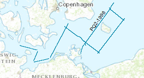
Processed seismic data from Baltic Sea with research ship M/V Polar Queen.The data format is Society of Exploration Geophysicists SEG Y. During the period from 14th to 28th of April 1996 BGR and GFZ chartered the Norwegian vessel M/V POLAR QUEEN for testing the new and updated marine seismic equipment of the BGR and for acquiring seismic lines. The operating area was the North Sea and Baltic Sea. The geophysical lines in the Baltic Sea were chosen as extended onshore DEKORP lines to evaluate the deep structure of the south western part of the Baltic Sea. For the seismic profiles a tuned source array consisting of 20 air guns in two linear strings with a total volume of 52 l was used. The recording length was 26 s, the sample rate 4 ms and the shot interval 30 s. This time triggering for the shot release was chosen, because all shots were also recorded onshore by seismic stations for wide angle/refraction acquisition (GFZ). During this leg 810 km reflection lines and additional 230 km pure shooting could be surveyed. The preliminary interpretation of the seismic single traces was restricted on the ship to the upper time range. The main structures in the southern Baltic Sea could be evaluated. A full interpretation especially of the deeper part is only possible after a processing due to the nature of the single traces and the S/N ratio.